

California, United States
Big Sur
Drive it slowly over a full day, stopping at pullouts, one or two short hikes and a cliffside lunch. We have mapped 2 sights, 1 activity and 3 outdoor spots here, each with a reason to go.

- Places
- 9
- Curated routes
- 1
- Best season
- Apr – Oct
- Warmest month
- September
- Coolest month
- January
- Wettest month
- December
2 See · 1 Do · 3 Outdoors · 2 Eat · 1 Drink
Pacific Coast Highway
from our route notes
21°C / 69°F avg high
14°C / 58°F avg high
about 106 mm rain
Climate: NASA POWER 2001–2025 averages.
Things to do in Big Sur
9 places from our curated routes, grouped by what you will do there. Each one has its own page with the address and full notes.
See
2 sights worth building a day around across Northern Big Sur and Big Sur. All 2 are free to visit.
 Photo: JINU · GoogleSee
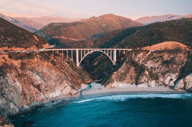
Bixby Creek Bridge
1932 concrete arch bridge, the most photographed spot on Highway 1.
Tip Use the north-side pullout; check Caltrans for Highway 1 closures before driving.
 Photo: Sarah Wulfeck · CC BY 2.0
Do
1 activity for when the group wants to do more than look in Northern Big Sur.
 Photo: Emilio · GoogleDo
Point Sur Lightstation
Guided tours of an 1889 lighthouse atop a volcanic rock.
Tip Tours run on set days only; meet at the gate on Highway 1.
Outdoors
3 outdoor spots for fresh air across Big Sur Valley, Big Sur and Julia Pfeiffer Burns SP.
 Photo: Bigsursectorstaff · CC0Outdoors
Pfeiffer Big Sur State Park
Redwood groves along the Big Sur River with trails to Pfeiffer Falls and Valley View.
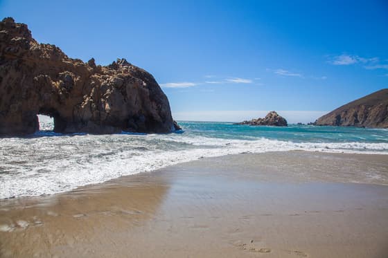 Photo: Bradley Weber · CC BY 2.0Outdoors
Pfeiffer Beach
Purple-streaked sand and Keyhole Arch at the end of narrow Sycamore Canyon Road.
Tip Unmarked turn; small lot fills fast. Arch glows near winter solstice.
 Photo: King of Hearts · CC BY-SA 4.0Outdoors
McWay Falls
80-foot waterfall dropping onto a cove beach, reached by a short flat path.
Tip Park inside Julia Pfeiffer Burns SP rather than on the highway shoulder.
Eat
Where we would book a table in Big Sur across Big Sur and Castro Canyon.
 Photo: California Historical Society · No restrictionsEat
Nepenthe
Clifftop restaurant since 1949 with long coastal views from the terrace.
Tip Order the Ambrosia burger; Cafe Kevah below is a lighter option.
 Photo: Ed Anderson, HABS photographer · Public domainEat
Deetjen's Big Sur Inn Restaurant
Candlelit dinners and hearty breakfasts in a 1930s redwood inn tucked into Castro Canyon.
Tip Dinner by reservation only; no dinner Wed-Thu.
Drink
Our picks for a drink in Big Sur in Big Sur Valley.
 Photo: Brian Lopez · Public domainDrink
Big Sur River Inn
Roadside inn where you can sit in chairs set in the river with a drink.
Tip Summer is best for the river chairs.
How to fit Big Sur into a trip
Big Sur is stop 3 of 6 on our Pacific Coast Highway route. Follow it as-is or lift Big Sur into your own plan.
Stop 3 of 6
Pacific Coast Highway
San Francisco to Los Angeles
- Trip length
- 6 days
- Best season
- Apr – Oct
- Pace
- easy
- Before: Monterey & Carmel
- Next: San Simeon
Getting here and onward
- Monterey & Carmel to Big SurMonterey & Carmel is about 37 km / 23 mi away in a straight line
- Big Sur to San SimeonSan Simeon is about 87 km / 54 mi away in a straight line
Distances are straight-line estimates between destination centers, not road distances.
Big Sur month by month
Average daily highs run from 14°C / 58°F in January to 21°C / 69°F in September. December is the wettest month, with about 106 mm of rain. Outlined months fall in the best season on our routes.
- Jan14° / 58°F average high
- Feb14° / 58°F average high
- Mar15° / 59°F average high
- Apr16° / 60°F average high, in our recommended season
- May17° / 62°F average high, in our recommended season
- Jun18° / 65°F average high, in our recommended season
- Jul19° / 67°F average high, in our recommended season
- Aug20° / 68°F average high, in our recommended season
- Sep21° / 69°F average high, in our recommended season
- Oct20° / 67°F average high, in our recommended season
- Nov17° / 63°F average high
- Dec15° / 58°F average high
Average daily highs, NASA POWER 2001–2025 averages. Big Sur weather and the best time to visit →
Near Big Sur
8 other destinations from our guides within about 300 km (186 mi), measured in a straight line.
- Monterey & CarmelCalifornia, United States37 km / 23 mi
- San SimeonCalifornia, United States87 km / 54 mi
- San FranciscoCalifornia, United States176 km / 109 mi
- The Embarcadero & Ferry BuildingCalifornia, United States177 km / 110 mi
- Lands End & Ocean BeachCalifornia, United States179 km / 111 mi
- SonomaCalifornia, United States232 km / 144 mi
- SolvangCalifornia, United States240 km / 149 mi
- NapaCalifornia, United States251 km / 156 mi
Big Sur questions, answered
How many days do you need in Big Sur?
Our route notes suggest a full day in Big Sur. On our Pacific Coast Highway route it is stop 3 of 6 in a 6-day trip. The listed visit times for our 9 places add up to roughly 12 hours, before travel between them, so you will need to choose.
What is Big Sur best known for?
Drive it slowly over a full day, stopping at pullouts, one or two short hikes and a cliffside lunch. Standouts on our list: Bixby Creek Bridge (1932 concrete arch bridge, the most photographed spot on Highway 1); Henry Miller Memorial Library (Bookstore and arts space in the redwoods honoring the writer); Pfeiffer Big Sur State Park (Redwood groves along the Big Sur River with trails to Pfeiffer Falls and Valley View).
When is the best time to visit Big Sur?
Our Pacific Coast Highway route is best Apr – Oct. NASA POWER 2001–2025 averages put the warmest highs in September (21°C / 69°F), the coolest in January (14°C / 58°F) and the most rain in December (about 106 mm).
What are the best things to do in Big Sur?
Start with Bixby Creek Bridge, Point Sur Lightstation, Pfeiffer Big Sur State Park, Pfeiffer Beach and Henry Miller Memorial Library. Our guide lists 9 places in all, from 2 sights, 1 activity, 3 outdoor spots, 2 places to eat and 1 bar or café.
Where should a group eat in Big Sur?
Our picks: Nepenthe (Big Sur); Deetjen's Big Sur Inn Restaurant (Castro Canyon). Order the Ambrosia burger; Cafe Kevah below is a lighter option (Nepenthe).
What is near Big Sur?
The closest destinations in our guides are Monterey & Carmel (about 37 km / 23 mi), San Simeon (about 87 km / 54 mi) and San Francisco (about 176 km / 109 mi). Distances are straight-line estimates, not road distances.
Plan Big Sur with your crew
Open the Pacific Coast Highway route in TripsCircle, invite friends with a link, settle which of these 9 places make the cut with a quick poll, then split costs and share one packing list.
Plan around Big Sur
- California travel hub
- United States travel hub
- Best Restaurants in California 54 places
- Best Bars & Cafés in California 30 places
- Top Things to Do in California 87 places
- Best Outdoor Spots in California 37 places
- Best Shopping in California 6 places
- Best Restaurants in United States 502 places
- Best Bars & Cafés in United States 258 places
- Top Things to Do in United States 919 places
- Best Outdoor Spots in United States 326 places
- Best Shopping in United States 71 places
- Big Sur weather by month
More in California
- Capitol Park & Midtown 6 places
- Old Sacramento Waterfront 8 places
- Healdsburg 9 places
- Santa Barbara 15 places
- South Lake Tahoe 6 places
- Tahoe City & Palisades 6 places
- Truckee 8 places
- West Hollywood 9 places
More in United States
- Red Rock Canyon 6 places
- The Strip 9 places
- Las Vegas 10 places
- Zion 10 places
- Zion NP 10 places
- Bryce Canyon 13 places
- Grand Canyon 9 places
- Yachats 10 places