
Old Quebec in snow, then the Laurentian slopes
This is leg 1 of 1, the opening leg.
 Get the app
Travel leg · Quebec City & Mont-Tremblant
Québec City and Mont-Tremblant sit about 267 km (166 mi) apart in a straight line, with Mont-Tremblant to the west. It is leg 1 of 1 on our Quebec City & Mont-Tremblant itinerary, a 6-day trip. Here is how long it takes by car, what to see on the way and where it fits in a real itinerary.

Road distance is estimated as 1.2–1.4× the straight line; drive time assumes average speeds of 65–95 km/h with no stops or traffic. These are rough estimates — check a maps app for the actual route.
We don't have live routing data, so the figures below are labelled estimates built from the straight-line distance. Use them to plan the day, then confirm in a maps app.
Most travelers on our Quebec City & Mont-Tremblant itinerary do this leg by car. We estimate 320–374 km (199–232 mi) of road and 3 h 15 min – 5 h 45 min behind the wheel, so check live traffic before you set off.
Fly into Quebec City (YQB) or Montreal (YUL). Old Quebec is walkable; the Funiculaire links the Upper and Lower Town. Rent a car for Montmorency Falls (15 min) and the Hotel de Glace (25 min). Quebec City to Mont-Tremblant is about 4 hrs via Highway 40 and Highway 15/117; Montreal to Mont-Tremblant is about 1 hr 30 min. Winter tires are required by law in Quebec from December 1 to March 15, and rental cars have them.
Open Québec City → Mont-Tremblant directions in Google Maps ↗
Picks from our curated guides at both ends.
Eastern Canada's big ski mountain and its lit-up village; 3 nights.

The highest skiable peak in the Laurentians, with over 100 runs on four sides and a gondola from the village.

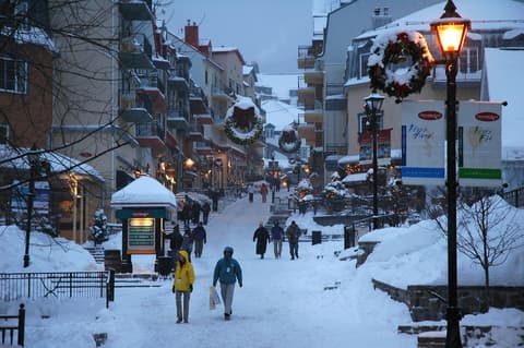
Car-free village of colorful buildings climbing the base of the mountain, hung with wreaths and lights in December.

Small white wooden chapel from 1942 at the foot of the village, decorated for Christmas services.

Long glacial lake below the mountain, frozen and snow-covered through most of winter.
Long-running village brewpub making its own beers, the classic apres-ski stop with burgers and sausages.
Ski-in, ski-out hotel at the top of the village, with an indoor-outdoor pool and the slopes at the door.
Walled French city in snow; 3 nights for the Upper and Lower Town and the Christmas market.

Landmark hotel above a boardwalk with sweeping views of the St. Lawrence.
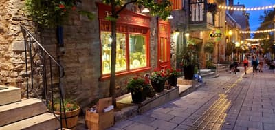
Narrow lower-town lanes of boutiques and bistros under the cliff, reached by funicular or Breakneck Stairs.

Battlefields park where the 1759 battle was fought, now lawns and lookouts over the river.
Where Québec City → Mont-Tremblant sits in the full itinerary. Highlighted stops are this leg.
Old Quebec in snow, then the Laurentian slopes
This is leg 1 of 1, the opening leg.
Going the other way? Mont-Tremblant to Québec City is the same 267 km in a straight line, heading east. Reverse directions in Google Maps ↗
Average daytime highs at both ends stay within 1°C of each other all year, so you can pack the same way for both.
| Measure | Jan | Feb | Mar | Apr | May | Jun | Jul | Aug | Sep | Oct | Nov | Dec |
|---|---|---|---|---|---|---|---|---|---|---|---|---|
| Québec City high | -7° | -5° | -1° | 8° | 17° | 22° | 24° | 23° | 20° | 12° | 4° | -3° |
| Mont-Tremblant high | -8° | -6° | -1° | 8° | 17° | 22° | 24° | 23° | 20° | 11° | 3° | -4° |
| Québec City rain | 66 | 64 | 72 | 93 | 95 | 113 | 123 | 108 | 109 | 119 | 90 | 95 |
| Mont-Tremblant rain | 83 | 71 | 82 | 96 | 93 | 106 | 99 | 96 | 98 | 115 | 93 | 104 |
Temperatures in °C, rain in mm per month. Long-term monthly averages from NASA POWER satellite climatology — a guide to typical conditions, not a forecast. Month headings link to Mont-Tremblant month guides.
Québec City is about 267 km (166 mi) from Mont-Tremblant in a straight line, with Mont-Tremblant to the west. By road, we estimate 320–374 km (199–232 mi), or 1.2–1.4 times the straight line. Check a maps app for the exact route.
An estimated 3 h 15 min – 5 h 45 min, assuming 320–374 km of road at average speeds of 65–95 km/h with no stops or traffic. It is not a routed time, so check a maps app on the day.
Our Quebec City & Mont-Tremblant itinerary includes this leg. Quebec City & Mont-Tremblant runs about 6 days across 2 stops, best in Late Nov – Mar.
Add this leg to a shared itinerary, poll the group on where to stop, split fuel and tickets, and keep everyone's packing list in one place in TripsCircle.