



Harbour city, sandstone cliffs and coral
This is leg 3 of 3, the final leg.
 Get the app
Travel leg · Sydney, Blue Mountains & the Reef
Cairns and Port Douglas & Daintree sit about 59 km (36 mi) apart in a straight line, with Port Douglas & Daintree to the north-west. It is leg 3 of 3 on our Sydney, Blue Mountains & the Reef itinerary, an 11-day trip. Here is how long it takes by car, what to see on the way and where it fits in a real itinerary.


Road distance is estimated as 1.2–1.4× the straight line; drive time assumes average speeds of 50–80 km/h with no stops or traffic. These are rough estimates — check a maps app for the actual route.
We don't have live routing data, so the figures below are labelled estimates built from the straight-line distance. Use them to plan the day, then confirm in a maps app.
Most travelers on our Sydney, Blue Mountains & the Reef itinerary do this leg by car. We estimate 70–82 km (44–51 mi) of road and 55 min – 1 h 45 min behind the wheel, so check live traffic before you set off.
Our Sydney, Blue Mountains & the Reef guide also mentions trains for parts of the trip. Whether a direct train links Cairns and Port Douglas depends on the line — check timetables.
Sydney's trains and ferries cover the city, and Sydney Trains run direct to Katoomba. Fly Sydney to Cairns (about 3 hours), then rent a car or use shuttles for the 70-minute coastal drive to Port Douglas.
Picks from our curated guides at both ends.
Resort town near the outer reef and the Daintree rainforest. Stay 2 to 3 days.

Ribbon reef on the outer edge of the Great Barrier Reef, reached by Quicksilver catamaran.

Small-boat cruise looking for saltwater crocodiles, birds and tree snakes on the river.

Wildlife park with tropical habitats, cassowaries, koalas and breakfast with the birds.

Weekly market in Anzac Park with crafts, tropical fruit and fresh juices.

Long-running Port Douglas restaurant with tropical Australian dishes and seafood.
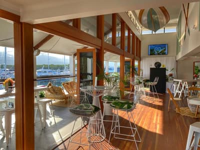
Waterfront brewery at the Crystalbrook Superyacht Marina with craft beers and marina views.
Tropical gateway to the Great Barrier Reef and the Wet Tropics rainforest. Stay 3 days.
Where Cairns → Port Douglas sits in the full itinerary. Highlighted stops are this leg.
Harbour city, sandstone cliffs and coral
This is leg 3 of 3, the final leg.
Going the other way? Port Douglas & Daintree to Cairns is the same 59 km in a straight line, heading south-east. Reverse directions in Google Maps ↗
The biggest gap comes in October, when Port Douglas & Daintree averages highs 2°C cooler than Cairns.
| Measure | Jan | Feb | Mar | Apr | May | Jun | Jul | Aug | Sep | Oct | Nov | Dec |
|---|---|---|---|---|---|---|---|---|---|---|---|---|
| Cairns high | 31° | 30° | 29° | 28° | 26° | 25° | 25° | 26° | 28° | 30° | 31° | 32° |
| Port Douglas high | 29° | 29° | 28° | 27° | 26° | 25° | 25° | 25° | 27° | 28° | 29° | 30° |
| Cairns rain | 352 | 392 | 392 | 191 | 103 | 63 | 53 | 31 | 31 | 62 | 86 | 179 |
| Port Douglas rain | 364 | 384 | 406 | 179 | 82 | 54 | 40 | 26 | 28 | 54 | 75 | 185 |
Temperatures in °C, rain in mm per month. Long-term monthly averages from NASA POWER satellite climatology — a guide to typical conditions, not a forecast. Month headings link to Port Douglas & Daintree month guides.
Cairns is about 59 km (36 mi) from Port Douglas & Daintree in a straight line, with Port Douglas & Daintree to the north-west. By road, we estimate 70–82 km (44–51 mi), or 1.2–1.4 times the straight line. Check a maps app for the exact route.
An estimated 55 min – 1 h 45 min, assuming 70–82 km of road at average speeds of 50–80 km/h with no stops or traffic. It is not a routed time, so check a maps app on the day.
Our Sydney, Blue Mountains & the Reef itinerary includes this leg. Sydney, Blue Mountains & the Reef runs about 11 days across 4 stops, best in May – Oct.
Add this leg to a shared itinerary, poll the group on where to stop, split fuel and tickets, and keep everyone's packing list in one place in TripsCircle.