

Sight Taftsville, Woodstock
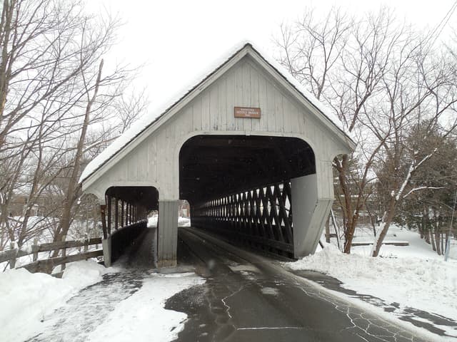
Taftsville Covered Bridge
A sight in Taftsville, Woodstock, free to visit and worth about 15 minutes.
Why go
1836 covered bridge over the Ottauquechee, one of the oldest in Vermont, on the road east to Quechee.
It is one of 9 curated places we feature in Woodstock, alongside 2 activities, 2 sights and 1 place to eat. The closest of our other picks is Billings Farm & Museum, 2.3 mi away as the crow flies. At about 15 minutes, it slots neatly between bigger plans.
- Type
- Sight
- Neighborhood
- Taftsville
- Price
- Free
- Time needed
- 15 min
Nearby
Our closest curated picks, including 1 beyond Woodstock. Distances are straight-line, not walking or driving.
- 1Billings Farm & Museum
Working Jersey dairy farm and museum with an 1890 farmhouse, decorated for Christmas weekends in December.
Activity · 2.3 mi straight-line - 2Billings Farm & Museum
Working dairy farm and museum on the edge of Woodstock, tied to the Marsh-Billings-Rockefeller park.
Sight · Vermont · 2.4 mi straight-line - 3F.H. Gillingham & Sons
General store on Elm Street run by the same family since 1886, selling Vermont food, hardware and gifts.
Shopping · 2.6 mi straight-line - 4Woodstock Inn & Resort
Inn on the green rebuilt by Laurance Rockefeller in 1969, with a big lobby fireplace and its own Nordic center.
Stay · 2.6 mi straight-line - 5Simon Pearce
Glassblowing workshop and restaurant in a brick mill above the Ottauquechee falls in Quechee.
Food · 2.6 mi straight-line - 6Woodstock Green
Oval village green ringed by Federal-style houses, the heart of Woodstock and the route of the Wassail parade.
Sight · 2.7 mi straight-line
On these curated routes
Taftsville Covered Bridge is a stop on our Stowe, Woodstock & the White Mountains route. Open it to see the full day-by-day plan.

More sights to see in Woodstock
Another curated sight in Woodstock. See the full Woodstock guide.
When to go
Average daily highs in Woodstock run from 28°F in January to 79°F in July; June is usually the wettest month.
Modelled monthly averages for Woodstock from NASA POWER, not a forecast. Full Woodstock weather by month.
Getting there
Map links open a live search for Taftsville Covered Bridge, so hours and directions come straight from the map app.
- Coordinates
- 43.63086, -72.46792
- Destination
- Woodstock, Vermont
Taftsville Covered Bridge: quick answers
How much time do you need at Taftsville Covered Bridge?
Plan on about 15 minutes at Taftsville Covered Bridge. That is our curated estimate for a typical visit; groups that linger will want more.
Is Taftsville Covered Bridge free?
Yes, we list Taftsville Covered Bridge as free to visit. Check locally before you go, since special exhibits, parking or tours can carry a fee.
Which TripsCircle routes include Taftsville Covered Bridge?
Taftsville Covered Bridge appears on Stowe, Woodstock & the White Mountains, a curated route you can open on TripsCircle and plan with your group.
Add Taftsville Covered Bridge to your crew's plan
Save it to a shared TripsCircle itinerary, settle the timing with a quick poll, and split the costs with everyone going to Woodstock.
Plan Woodstock
- Woodstock travel guide 9 places
- Best time to visit Woodstock weather by month
- Stowe to Woodstock 59 mi straight-line
- Woodstock to White Mountains 75 mi straight-line
Lists & regions
Also in Woodstock
- Saskadena Six Activity
- Marsh-Billings-Rockefeller National Historical Park Outdoors
Curated recommendation, not live listing data. Confirm hours, prices, bookings and access before you go.