
Snowy inns, covered bridges and ski hills
This is leg 2 of 2, the final leg.
 Get the app
Travel leg · Stowe, Woodstock & the White Mountains
Woodstock and White Mountains sit about 121 km (75 mi) apart in a straight line, with White Mountains to the north-east. It is leg 2 of 2 on our Stowe, Woodstock & the White Mountains itinerary, a 6-day trip. Here is how long it takes by car, what to see on the way and where it fits in a real itinerary.

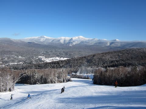
Road distance is estimated as 1.2–1.4× the straight line; drive time assumes average speeds of 65–95 km/h with no stops or traffic. These are rough estimates — check a maps app for the actual route.
We don't have live routing data, so the figures below are labelled estimates built from the straight-line distance. Use them to plan the day, then confirm in a maps app.
Most travelers on our Stowe, Woodstock & the White Mountains itinerary do this leg by car. We estimate 145–169 km (90–105 mi) of road and 1 h 30 min – 2 h 30 min behind the wheel, so check live traffic before you set off.
Fly into Burlington (BTV), 45 minutes from Stowe, and out of Portland, Maine (PWM), about 1.5 hours from Jackson. Stowe to Woodstock is about 1 hour 45 minutes via I-89; Woodstock to Bretton Woods is about 2 hours via I-89, I-91 and I-93; Bretton Woods to Jackson is 45 minutes through Crawford Notch on US-302 and NH-16. Rent an all-wheel-drive car with winter tires. In Stowe, the free Mountain Road Shuttle links the village and the ski resort in winter.
Open Woodstock → White Mountains directions in Google Maps ↗
Picks from our curated guides at both ends, plus 6 places near the straight-line path.
Bretton Woods, Crawford Notch and Jackson village; 2 nights under Mount Washington.
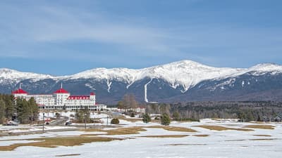
Red-roofed 1902 grand hotel at Bretton Woods, now the Omni Mount Washington Resort, facing the Presidential Range.

Steep mountain pass carrying US-302 between granite walls, with frozen waterfalls and snowshoe trails in winter.

Red 1876 covered bridge over the Ellis River that serves as the entrance to Jackson village.
New Hampshire's largest ski area, with long cruising runs facing Mount Washington and a big Nordic center.
Brewpub on the main road into North Conway, serving smoked barbecue with its own beers.
The world's first mountain-climbing cog railway, from 1869; winter trains climb partway up to Waumbek Station.
These places from our other itineraries sit within about 18 km of the straight line between Woodstock and White Mountains. The road may not pass them directly, so check how far off your route they are.

Brewpub with an outdoor patio in North Woodstock, a natural end to a notch day.

12-minute gondola up Loon Peak with an observation tower over 24 of NH's 4,000-footers.

Two-mile loop on boardwalks through a granite gorge with waterfalls and covered bridges.

Family-run since 1938, serving pancakes from house-ground flours with mountain views.

34.5-mile scenic road between Lincoln and Conway with no services and wide overlooks.

Short, steep hike to a ledge over Echo Lake and the notch, a classic foliage photo spot.
A village green, covered bridges and a working farm; 2 nights, ideally Wassail Weekend.

Town-lattice covered bridge built in 1969 over the Ottauquechee River, a short walk from the green.

Working Jersey dairy farm and museum with an 1890 farmhouse, decorated for Christmas weekends in December.

Glassblowing workshop and restaurant in a brick mill above the Ottauquechee falls in Quechee.
Where Woodstock → White Mountains sits in the full itinerary. Highlighted stops are this leg.
Snowy inns, covered bridges and ski hills
This is leg 2 of 2, the final leg.
Going the other way? White Mountains to Woodstock is the same 121 km in a straight line, heading south-west. Reverse directions in Google Maps ↗
The biggest gap comes in March, when White Mountains averages highs 13°C cooler than Woodstock.
| Measure | Jan | Feb | Mar | Apr | May | Jun | Jul | Aug | Sep | Oct | Nov | Dec |
|---|---|---|---|---|---|---|---|---|---|---|---|---|
| Woodstock high | -2° | -1° | 4° | 12° | 19° | 23° | 26° | 25° | 22° | 14° | 7° | 1° |
| White Mountains high | -15° | -14° | -9° | -1° | 7° | 11° | 14° | 13° | 10° | 2° | -5° | -12° |
| Woodstock rain | 63 | 69 | 76 | 86 | 95 | 118 | 110 | 99 | 91 | 118 | 81 | 95 |
| White Mountains rain | 67 | 70 | 76 | 97 | 109 | 132 | 119 | 113 | 91 | 130 | 94 | 103 |
Temperatures in °C, rain in mm per month. Long-term monthly averages from NASA POWER satellite climatology — a guide to typical conditions, not a forecast. Month headings link to White Mountains month guides.
Woodstock is about 121 km (75 mi) from White Mountains in a straight line, with White Mountains to the north-east. By road, we estimate 145–169 km (90–105 mi), or 1.2–1.4 times the straight line. Check a maps app for the exact route.
An estimated 1 h 30 min – 2 h 30 min, assuming 145–169 km of road at average speeds of 65–95 km/h with no stops or traffic. It is not a routed time, so check a maps app on the day.
Near the straight-line path we have 6 places from our curated guides, including Woodstock Inn Brewery (New Hampshire), Loon Mountain Scenic Gondola (New Hampshire), Flume Gorge (New Hampshire), Polly's Pancake Parlor (New Hampshire). The road may not pass them directly, so check the detour.
Our Stowe, Woodstock & the White Mountains itinerary includes this leg. Stowe, Woodstock & the White Mountains runs about 6 days across 3 stops, best in Dec – Mar.
Add this leg to a shared itinerary, poll the group on where to stop, split fuel and tickets, and keep everyone's packing list in one place in TripsCircle.