


Cenotes, Mayan ruins & a seven-color lagoon
This is leg 2 of 2, the final leg.
 Get the app
Travel leg · Tulum & Riviera Maya
Tulum and Bacalar sit about 197 km (122 mi) apart in a straight line, with Bacalar to the south-west. It is leg 2 of 2 on our Tulum & Riviera Maya itinerary, a 7-day trip. Here is how long it takes by car, what to see on the way and where it fits in a real itinerary.

Road distance is estimated as 1.2–1.4× the straight line; drive time assumes average speeds of 65–95 km/h with no stops or traffic. These are rough estimates — check a maps app for the actual route.
We don't have live routing data, so the figures below are labelled estimates built from the straight-line distance. Use them to plan the day, then confirm in a maps app.
Most travelers on our Tulum & Riviera Maya itinerary do this leg by car. We estimate 236–275 km (147–171 mi) of road and 2 h 30 min – 4 h 15 min behind the wheel, so check live traffic before you set off.
From Cancún airport, shuttles, buses and rental cars run down the coast through Playa del Carmen and Tulum. Colectivos and taxis cover short hops. Bacalar is a longer drive south of Tulum, and many groups rent a car for the whole route.
Picks from our curated guides at both ends.
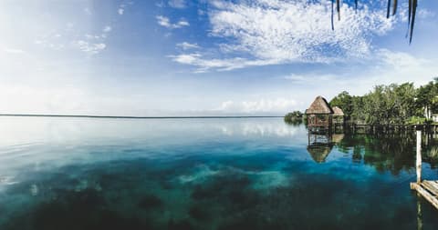
Spend 2 days on the lagoon: a sailboat tour, cenote swims and slow lakeside meals.

Sail the lagoon of seven colors to the Pirates' Channel and Bird Island.

Section of lagoon with a gentle current you can float down.
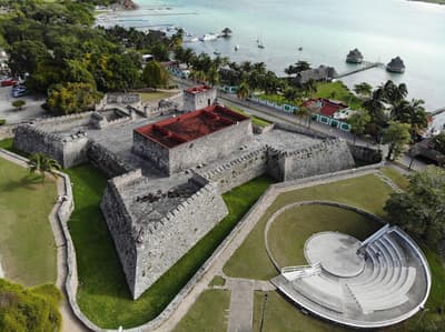
18th-century fort built against pirates, with a museum overlooking the lagoon.

Vegan restaurant by the fort with lagoon views.

Lagoon-front Japanese-fusion spot with sushi, mezcal and signature cocktails, open until midnight. Formerly Nao.

90-m deep cenote for swimming, with a lakeside restaurant.
Spend 2–3 days: the cliffside ruins early, cenote swims, a biosphere boat trip, and beach-zone dinners.
Where Tulum → Bacalar sits in the full itinerary. Highlighted stops are this leg.
Cenotes, Mayan ruins & a seven-color lagoon
This is leg 2 of 2, the final leg.
Going the other way? Bacalar to Tulum is the same 197 km in a straight line, heading north-east. Reverse directions in Google Maps ↗
Average daytime highs at both ends stay within 1°C of each other all year, so you can pack the same way for both.
| Measure | Jan | Feb | Mar | Apr | May | Jun | Jul | Aug | Sep | Oct | Nov | Dec |
|---|---|---|---|---|---|---|---|---|---|---|---|---|
| Tulum high | 27° | 28° | 29° | 30° | 31° | 30° | 30° | 30° | 29° | 29° | 27° | 27° |
| Bacalar high | 27° | 28° | 29° | 31° | 31° | 30° | 30° | 30° | 30° | 29° | 28° | 27° |
| Tulum rain | 50 | 41 | 41 | 41 | 110 | 181 | 116 | 149 | 185 | 208 | 111 | 60 |
| Bacalar rain | 68 | 40 | 38 | 39 | 130 | 201 | 120 | 154 | 172 | 221 | 128 | 81 |
Temperatures in °C, rain in mm per month. Long-term monthly averages from NASA POWER satellite climatology — a guide to typical conditions, not a forecast. Month headings link to Bacalar month guides.
Tulum is about 197 km (122 mi) from Bacalar in a straight line, with Bacalar to the south-west. By road, we estimate 236–275 km (147–171 mi), or 1.2–1.4 times the straight line. Check a maps app for the exact route.
An estimated 2 h 30 min – 4 h 15 min, assuming 236–275 km of road at average speeds of 65–95 km/h with no stops or traffic. It is not a routed time, so check a maps app on the day.
Our Tulum & Riviera Maya itinerary includes this leg. Tulum & Riviera Maya runs about 7 days across 3 stops, best in Dec – Apr.
Add this leg to a shared itinerary, poll the group on where to stop, split fuel and tickets, and keep everyone's packing list in one place in TripsCircle.