
Desert coast, surf towns and Sea of Cortez islands
This is leg 1 of 2, the opening leg.
 Get the app
Travel leg · Los Cabos, Todos Santos & La Paz
Los Cabos and Todos Santos sit about 66 km (41 mi) apart in a straight line, with Todos Santos to the north-west. It is leg 1 of 2 on our Los Cabos, Todos Santos & La Paz itinerary, an 8-day trip. Here is how long it takes by car, what to see on the way and where it fits in a real itinerary.

Road distance is estimated as 1.2–1.4× the straight line; drive time assumes average speeds of 50–80 km/h with no stops or traffic. These are rough estimates — check a maps app for the actual route.
We don't have live routing data, so the figures below are labelled estimates built from the straight-line distance. Use them to plan the day, then confirm in a maps app.
Most travelers on our Los Cabos, Todos Santos & La Paz itinerary do this leg by car. We estimate 79–92 km (49–57 mi) of road and 60 min – 1 h 45 min behind the wheel, so check live traffic before you set off.
Rent a car at Los Cabos airport; Highway 19 reaches Todos Santos in about an hour and La Paz in another hour. Boat tours handle Espíritu Santo and El Arco. Avoid driving rural roads after dark because of livestock.
Picks from our curated guides at both ends.
One or two nights for galleries, surf beaches and a long dinner.

Pueblo Mágico of adobe buildings, galleries and the mission church around the plaza.

Sheltered Pacific beach with beginner surf, board rentals and beach bars.

Local conservation group releases hatchlings at sunset in season.

Javier Plascencia's garden restaurant with wood-fired Baja cooking from local farms.

Open-air café and juice bar near the beach, a casual gathering spot.

Mid-century hotel on Calle Juárez with a courtyard bar and boutique.
Stay 3 nights, ideally in San José del Cabo, with a boat day in Cabo San Lucas and a day trip to Cabo Pulmo.

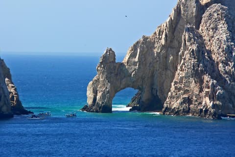
Granite arch at Land's End where the Pacific meets the Sea of Cortez, seen by water taxi or glass-bottom boat.

Calm, swimmable beach facing El Arco, lined with beach clubs and water sports.

Boat tours to see humpbacks breaching off the cape between December and April.
Where Los Cabos → Todos Santos sits in the full itinerary. Highlighted stops are this leg.
Desert coast, surf towns and Sea of Cortez islands
This is leg 1 of 2, the opening leg.
Going the other way? Todos Santos to Los Cabos is the same 66 km in a straight line, heading south-east. Reverse directions in Google Maps ↗
The biggest gap comes in June, when Todos Santos averages highs 7°C warmer than Los Cabos.
| Measure | Jan | Feb | Mar | Apr | May | Jun | Jul | Aug | Sep | Oct | Nov | Dec |
|---|---|---|---|---|---|---|---|---|---|---|---|---|
| Los Cabos high | 24° | 24° | 24° | 25° | 26° | 28° | 30° | 30° | 30° | 29° | 27° | 24° |
| Todos Santos high | 26° | 26° | 29° | 30° | 33° | 34° | 35° | 34° | 33° | 32° | 30° | 26° |
| Los Cabos rain | 9 | 11 | 3 | 2 | 1 | 3 | 19 | 60 | 99 | 26 | 18 | 11 |
| Todos Santos rain | 7 | 9 | 2 | 0 | 0 | 2 | 22 | 61 | 108 | 27 | 17 | 8 |
Temperatures in °C, rain in mm per month. Long-term monthly averages from NASA POWER satellite climatology — a guide to typical conditions, not a forecast. Month headings link to Todos Santos month guides.
Los Cabos is about 66 km (41 mi) from Todos Santos in a straight line, with Todos Santos to the north-west. By road, we estimate 79–92 km (49–57 mi), or 1.2–1.4 times the straight line. Check a maps app for the exact route.
An estimated 60 min – 1 h 45 min, assuming 79–92 km of road at average speeds of 50–80 km/h with no stops or traffic. It is not a routed time, so check a maps app on the day.
Our Los Cabos, Todos Santos & La Paz itinerary includes this leg. Los Cabos, Todos Santos & La Paz runs about 8 days across 3 stops, best in Nov – Apr.
Add this leg to a shared itinerary, poll the group on where to stop, split fuel and tickets, and keep everyone's packing list in one place in TripsCircle.