


Delhi, the Taj, Jaipur forts and Udaipur lakes
This is leg 2 of 3.
 Get the app
Travel leg · Golden Triangle & Rajasthan
Agra and Jaipur sit about 222 km (138 mi) apart in a straight line, with Jaipur to the west. It is leg 2 of 3 on our Golden Triangle & Rajasthan itinerary, an 11-day trip. Here is how long it takes by train, what to see on the way and where it fits in a real itinerary.

Road distance is estimated as 1.2–1.4× the straight line; drive time assumes average speeds of 65–95 km/h with no stops or traffic. These are rough estimates — check a maps app for the actual route.
We don't have live routing data, so the figures below are labelled estimates built from the straight-line distance. Use them to plan the day, then confirm in a maps app.
Our Golden Triangle & Rajasthan itinerary is planned around rail, so a train is the likely way to cover this leg. Timetables and direct connections vary — check the operator before you book.
Driving is an estimated 266–311 km (165–193 mi) and 2 h 45 min – 4 h 45 min at typical average speeds, not a routed time.
Fast trains such as the Gatimaan and Vande Bharat expresses link Delhi and Agra in under two hours, and trains or a hired car with driver connect Agra to Jaipur. Jaipur to Udaipur is about six hours by road or a short flight. Use app cabs or prepaid taxis in cities.
Picks from our curated guides at both ends.
Hill forts, the Pink City bazaars and royal palaces. Stay 2–3 nights.

Hilltop palace-fort of courtyards, mirrored halls and ramparts above Maota Lake.

Old-city market lane for jewelry, gems, block-printed textiles and bangles.

Vegetarian restaurant and sweet shop since 1954, known for Rajasthani thalis and ghewar.

Peacock-blue Italian-style bar and garden at the Narain Niwas Palace hotel.

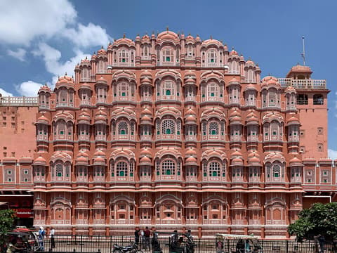
Five-story pink honeycomb facade with 953 windows, built so royal women could watch street life.

Royal residence with museums of textiles and arms, plus the painted Peacock Gate.
The Taj Mahal and the Mughal forts around it. Stay 1–2 nights.
Where Agra → Jaipur sits in the full itinerary. Highlighted stops are this leg.
Delhi, the Taj, Jaipur forts and Udaipur lakes
This is leg 2 of 3.
Going the other way? Jaipur to Agra is the same 222 km in a straight line, heading east. Reverse directions in Google Maps ↗
The biggest gap comes in May, when Jaipur averages highs 2°C cooler than Agra.
| Measure | Jan | Feb | Mar | Apr | May | Jun | Jul | Aug | Sep | Oct | Nov | Dec |
|---|---|---|---|---|---|---|---|---|---|---|---|---|
| Agra high | 23° | 27° | 34° | 40° | 44° | 43° | 37° | 34° | 34° | 33° | 29° | 24° |
| Jaipur high | 22° | 26° | 32° | 38° | 41° | 40° | 36° | 33° | 34° | 33° | 28° | 24° |
| Agra rain | 13 | 12 | 11 | 9 | 18 | 69 | 185 | 181 | 97 | 21 | 5 | 6 |
| Jaipur rain | 5 | 10 | 10 | 10 | 18 | 61 | 158 | 172 | 63 | 10 | 4 | 3 |
Temperatures in °C, rain in mm per month. Long-term monthly averages from NASA POWER satellite climatology — a guide to typical conditions, not a forecast. Month headings link to Jaipur month guides.
Agra is about 222 km (138 mi) from Jaipur in a straight line, with Jaipur to the west. By road, we estimate 266–311 km (165–193 mi), or 1.2–1.4 times the straight line. Check a maps app for the exact route.
An estimated 2 h 45 min – 4 h 45 min, assuming 266–311 km of road at average speeds of 65–95 km/h with no stops or traffic. It is not a routed time, so check a maps app on the day. Our itinerary leans on rail, so check train times too.
Our Golden Triangle & Rajasthan itinerary includes this leg. Golden Triangle & Rajasthan runs about 11 days across 4 stops, best in Oct – Mar.
Add this leg to a shared itinerary, poll the group on where to stop, split fuel and tickets, and keep everyone's packing list in one place in TripsCircle.