


Amman, the Rose City, red desert and salt sea
This is leg 2 of 3.
 Get the app
Travel leg · Jordan: Petra, Wadi Rum & the Dead Sea
Petra & Wadi Musa and Wadi Rum sit about 84 km (52 mi) apart in a straight line, with Wadi Rum to the south. It is leg 2 of 3 on our Jordan: Petra, Wadi Rum & the Dead Sea itinerary, an 8-day trip. Here is how long it takes by car, what to see on the way and where it fits in a real itinerary.


Road distance is estimated as 1.2–1.4× the straight line; drive time assumes average speeds of 50–80 km/h with no stops or traffic. These are rough estimates — check a maps app for the actual route.
We don't have live routing data, so the figures below are labelled estimates built from the straight-line distance. Use them to plan the day, then confirm in a maps app.
Most travelers on our Jordan: Petra, Wadi Rum & the Dead Sea itinerary do this leg by car. We estimate 100–117 km (62–73 mi) of road and 1 h 15 min – 2 h 15 min behind the wheel, so check live traffic before you set off.
A rental car is easy on Jordan's good highways; the Desert Highway is fastest and the King's Highway is the scenic route. JETT buses link Amman, Petra and Aqaba, and Wadi Rum camps arrange pickups from the visitor center.
Picks from our curated guides at both ends.
Red sand desert of sandstone mountains and Bedouin camps. Stay 1–2 nights.

Half- or full-day 4x4 trips to dunes, canyons, rock bridges and inscriptions.

Narrow cleft with Nabataean and Thamudic rock carvings.

Small natural arch you can climb onto for photos over the sand.

Chicken, lamb and vegetables slow-cooked in a pit under the sand, served at most camps.
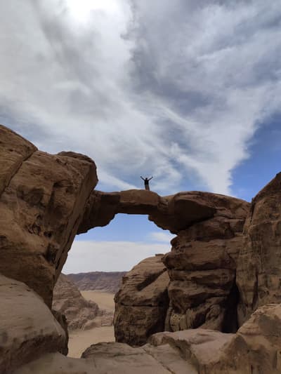
Guided scramble to one of the desert's highest natural arches.

Dunes banked against Jebel Umm Ishrin where you can climb or sandboard.
The Nabataean rock-cut city and its gateway town. Stay 2–3 nights.
Where Petra → Wadi Rum sits in the full itinerary. Highlighted stops are this leg.
Amman, the Rose City, red desert and salt sea
This is leg 2 of 3.
Going the other way? Wadi Rum to Petra & Wadi Musa is the same 84 km in a straight line, heading north. Reverse directions in Google Maps ↗
The biggest gap comes in August, when Wadi Rum averages highs 3°C warmer than Petra & Wadi Musa.
| Measure | Jan | Feb | Mar | Apr | May | Jun | Jul | Aug | Sep | Oct | Nov | Dec |
|---|---|---|---|---|---|---|---|---|---|---|---|---|
| Petra high | 13° | 15° | 20° | 24° | 29° | 33° | 34° | 34° | 32° | 27° | 20° | 15° |
| Wadi Rum high | 15° | 17° | 22° | 27° | 32° | 36° | 37° | 37° | 34° | 29° | 22° | 16° |
| Petra rain | 45 | 36 | 19 | 10 | 4 | 0 | 0 | 0 | 1 | 7 | 15 | 26 |
| Wadi Rum rain | 8 | 8 | 4 | 3 | 1 | 0 | 0 | 1 | 1 | 3 | 5 | 5 |
Temperatures in °C, rain in mm per month. Long-term monthly averages from NASA POWER satellite climatology — a guide to typical conditions, not a forecast. Month headings link to Wadi Rum month guides.
Petra & Wadi Musa is about 84 km (52 mi) from Wadi Rum in a straight line, with Wadi Rum to the south. By road, we estimate 100–117 km (62–73 mi), or 1.2–1.4 times the straight line. Check a maps app for the exact route.
An estimated 1 h 15 min – 2 h 15 min, assuming 100–117 km of road at average speeds of 50–80 km/h with no stops or traffic. It is not a routed time, so check a maps app on the day.
Our Jordan: Petra, Wadi Rum & the Dead Sea itinerary includes this leg. Jordan: Petra, Wadi Rum & the Dead Sea runs about 8 days across 4 stops, best in Mar – May, Sep – Nov.
Add this leg to a shared itinerary, poll the group on where to stop, split fuel and tickets, and keep everyone's packing list in one place in TripsCircle.