
Design districts, dunes & Great Lakes culture
This is leg 2 of 2, the final leg.
 Get the app
Travel leg · Indiana & Ohio City-Nature Loop
Indiana Dunes and Cleveland sit about 446 km (277 mi) apart in a straight line, with Cleveland to the east. It is leg 2 of 2 on our Indiana & Ohio City-Nature Loop itinerary, a 6-day trip. Here is how long it takes by car, what to see on the way and where it fits in a real itinerary.

Road distance is estimated as 1.2–1.4× the straight line; drive time assumes average speeds of 65–95 km/h with no stops or traffic. These are rough estimates — check a maps app for the actual route.
We don't have live routing data, so the figures below are labelled estimates built from the straight-line distance. Use them to plan the day, then confirm in a maps app.
Most travelers on our Indiana & Ohio City-Nature Loop itinerary do this leg by car. We estimate 535–624 km (333–388 mi) of road and 5 h 45 min – 9 h 30 min behind the wheel, so check live traffic before you set off.
Driving is the usual choice, with interstates linking Indianapolis, the dunes and Cleveland. The dunes area is the hardest to reach without a car. In Indianapolis and Cleveland, downtown and nearby neighborhoods can be explored on foot.
Picks from our curated guides at both ends.
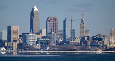
Spend two days: lakefront museums, Ohio City food and beer, University Circle, and a Cuyahoga Valley waterfall.

I.M. Pei pyramid on the lake with stage costumes, instruments and hall of inductees.

1912 market hall with butchers, bakers and pierogi and gyro stands.
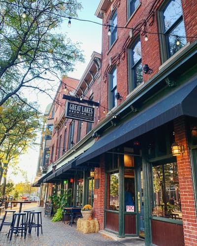
Ohio's pioneering craft brewery; brewpub in Ohio City with Edmund Fitzgerald Porter on tap.
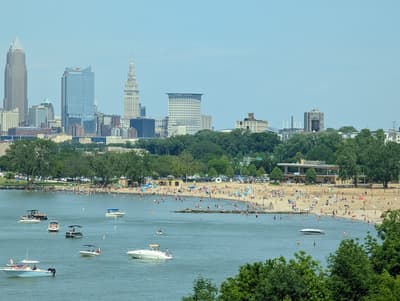
Lakefront park with a beach, skyline view and sunset over Lake Erie.
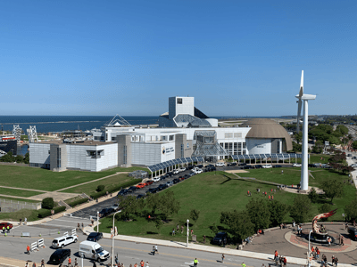
Hands-on science museum next door, with the NASA Glenn visitor center.

Family diner since 1964 serving towering corned beef sandwiches.
Give it a full day: one big dune climb, a beach afternoon and a quieter marsh or farm trail.

Joint national and state park visitor center for maps, passes and trail conditions.

1.5-mile climb over the state park's three tallest dunes, 552 vertical feet in sand.

Lifeguarded national park beach with views of the Chicago skyline across Lake Michigan.
Where Indiana Dunes → Cleveland sits in the full itinerary. Highlighted stops are this leg.
Design districts, dunes & Great Lakes culture
This is leg 2 of 2, the final leg.
Going the other way? Cleveland to Indiana Dunes is the same 446 km in a straight line, heading west. Reverse directions in Google Maps ↗
The biggest gap comes in April, when Cleveland averages highs 3°C cooler than Indiana Dunes.
| Measure | Jan | Feb | Mar | Apr | May | Jun | Jul | Aug | Sep | Oct | Nov | Dec |
|---|---|---|---|---|---|---|---|---|---|---|---|---|
| Indiana Dunes high | 0° | 1° | 8° | 15° | 20° | 26° | 28° | 28° | 24° | 17° | 9° | 3° |
| Cleveland high | 0° | 1° | 5° | 11° | 17° | 23° | 26° | 26° | 23° | 16° | 9° | 3° |
| Indiana Dunes rain | 58 | 56 | 62 | 90 | 111 | 98 | 101 | 108 | 80 | 95 | 65 | 60 |
| Cleveland rain | 58 | 56 | 71 | 80 | 96 | 96 | 92 | 81 | 88 | 85 | 68 | 66 |
Temperatures in °C, rain in mm per month. Long-term monthly averages from NASA POWER satellite climatology — a guide to typical conditions, not a forecast. Month headings link to Cleveland month guides.
Indiana Dunes is about 446 km (277 mi) from Cleveland in a straight line, with Cleveland to the east. By road, we estimate 535–624 km (333–388 mi), or 1.2–1.4 times the straight line. Check a maps app for the exact route.
An estimated 5 h 45 min – 9 h 30 min, assuming 535–624 km of road at average speeds of 65–95 km/h with no stops or traffic. It is not a routed time, so check a maps app on the day.
Our Indiana & Ohio City-Nature Loop itinerary includes this leg. Indiana & Ohio City-Nature Loop runs about 6 days across 3 stops, best in May – Oct.
Add this leg to a shared itinerary, poll the group on where to stop, split fuel and tickets, and keep everyone's packing list in one place in TripsCircle.