
Steakhouses, First Avenue and a frozen waterfall
This is leg 1 of 1, the opening leg.
 Get the app
Travel leg · Minneapolis New Year's Eve
Downtown Minneapolis & the Riverfront and Minnehaha Falls sit about 8.1 km (5 mi) apart in a straight line, with Minnehaha Falls to the south-east. It is leg 1 of 1 on our Minneapolis New Year's Eve itinerary, a 3-day trip. It is a short hop across town, easy by local transit, ride share or on foot.

Road distance is estimated as 1.2–1.4× the straight line; drive time assumes average speeds of 25–45 km/h with no stops or traffic. These are rough estimates — check a maps app for the actual route.
We don't have live routing data, so the figures below are labelled estimates built from the straight-line distance. Use them to plan the day, then confirm in a maps app.
This is a short in-city hop of about 8.1 km in a straight line. Our Minneapolis New Year's Eve guide suggests public transit and ride shares or taxis for getting around. By car it takes an estimated 15–25 min without traffic.
Fly into Minneapolis-St. Paul (MSP); the METRO Blue Line light rail reaches downtown in about 25 minutes and stops at 46th Street and 50th Street-Minnehaha Park for the falls. The skyway system links most downtown hotels, restaurants and the IDS Center indoors, so you can cross downtown without going outside. Metro Transit often extends service on New Year's Eve; check its site. Rideshare surges after midnight, and street parking rules tighten when snow emergencies are declared.
Open Downtown Minneapolis → Minnehaha Falls directions in Google Maps ↗
Picks from our curated guides at both ends.
A slow Jan 1: a frozen 53-foot waterfall, river bluffs, a lake loop and a diner.

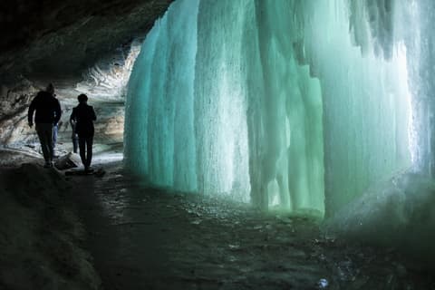
53-foot waterfall in Minnehaha Regional Park that freezes into columns of blue ice most winters.
Diner in a restored 1957 dining car on East Lake Street, known for hi-top doughnuts and big breakfasts.
Free encyclopedic art museum with period rooms and collections from ancient China to modern America.
Park at the confluence of the Mississippi and Minnesota rivers, with trails on Pike Island and through river-bottom woods.

Lake on the Grand Rounds with a 2.7-mile loop path, popular for winter walks and ice fishing.
Wooded bluffs along West River Parkway north of Minnehaha, the only true gorge on the Mississippi.
Two nights downtown for the riverfront skyline, steak dinners and a midnight show.

1883 stone railroad bridge, now a walkway over St. Anthony Falls, with the classic view of the skyline and the Gold Medal Flour sign.

1929 Art Deco obelisk modeled on the Washington Monument, now the W Minneapolis hotel with an open-air observation deck.
Downtown music club since 1970, famous from Prince's Purple Rain, with silver stars of past performers on its outside walls.
Where Downtown Minneapolis → Minnehaha Falls sits in the full itinerary. Highlighted stops are this leg.
Steakhouses, First Avenue and a frozen waterfall
This is leg 1 of 1, the opening leg.
Going the other way? Minnehaha Falls to Downtown Minneapolis & the Riverfront is the same 8.1 km in a straight line, heading north-west. Reverse directions in Google Maps ↗
Downtown Minneapolis & the Riverfront is about 8.1 km (5 mi) from Minnehaha Falls in a straight line, with Minnehaha Falls to the south-east. By road, we estimate 9.7–11 km (6–7 mi), or 1.2–1.4 times the straight line. Check a maps app for the exact route.
An estimated 15–25 min, assuming 9.7–11 km of road at average speeds of 25–45 km/h with no stops or traffic. It is not a routed time, so check a maps app on the day.
Our Minneapolis New Year's Eve itinerary includes this leg. Minneapolis New Year's Eve runs about 3 days across 2 stops, best in Dec 30 – Jan 1.
Add this leg to a shared itinerary, poll the group on where to stop, split fuel and tickets, and keep everyone's packing list in one place in TripsCircle.