
Palaces, tapas bars and a gorge-top town
This is leg 2 of 3.
 Get the app
Travel leg · Andalusia: Moorish Cities & Ronda
Córdoba and Granada sit about 131 km (81 mi) apart in a straight line, with Granada to the south-east. It is leg 2 of 3 on our Andalusia: Moorish Cities & Ronda itinerary, a 10-day trip. Here is how long it takes by car, what to see on the way and where it fits in a real itinerary.


Road distance is estimated as 1.2–1.4× the straight line; drive time assumes average speeds of 65–95 km/h with no stops or traffic. These are rough estimates — check a maps app for the actual route.
We don't have live routing data, so the figures below are labelled estimates built from the straight-line distance. Use them to plan the day, then confirm in a maps app.
Most travelers on our Andalusia: Moorish Cities & Ronda itinerary do this leg by car. We estimate 157–183 km (97–114 mi) of road and 1 h 45 min – 2 h 45 min behind the wheel, so check live traffic before you set off.
Our Andalusia: Moorish Cities & Ronda guide also mentions trains for parts of the trip. Whether a direct train links Córdoba and Granada depends on the line — check timetables.
High-speed trains link Seville, Córdoba and Granada in under 2 hours each. Hire a car for Ronda and the white towns, or take the train from Granada to Ronda via Antequera.
Picks from our curated guides at both ends.
Alhambra city under the Sierra Nevada; 2–3 nights.

Nasrid palaces, fortress and gardens on a hill above the city.

Old Moorish quarter of steep lanes and carmen houses with walled gardens.

Mainland Spain's highest range; ski in winter, hike in summer, 45 minutes away.

Busy bar for fried fish and seafood tapas.

Old bodega with barrels and hams, pouring local wine and vermouth.
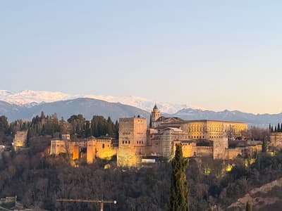
Plaza in the Albaicín with a direct view of the Alhambra and mountains.
Compact old town; 2 nights for the Mezquita and patios.

Great mosque of red-and-white arches with a Renaissance cathedral built inside.

Old Jewish quarter of whitewashed lanes, a medieval synagogue and pot-lined alleys.

Old tavern serving salmorejo, aubergine with honey and stews around a patio.
Where Córdoba → Granada sits in the full itinerary. Highlighted stops are this leg.
Palaces, tapas bars and a gorge-top town
This is leg 2 of 3.
Going the other way? Granada to Córdoba is the same 131 km in a straight line, heading north-west. Reverse directions in Google Maps ↗
The biggest gap comes in August, when Granada averages highs 6°C cooler than Córdoba.
| Measure | Jan | Feb | Mar | Apr | May | Jun | Jul | Aug | Sep | Oct | Nov | Dec |
|---|---|---|---|---|---|---|---|---|---|---|---|---|
| Córdoba high | 15° | 16° | 19° | 23° | 28° | 34° | 38° | 38° | 32° | 26° | 19° | 15° |
| Granada high | 12° | 13° | 16° | 19° | 23° | 29° | 32° | 32° | 27° | 22° | 16° | 13° |
| Córdoba rain | 46 | 49 | 65 | 53 | 33 | 5 | 1 | 7 | 28 | 69 | 66 | 62 |
| Granada rain | 40 | 43 | 56 | 42 | 24 | 4 | 1 | 3 | 26 | 47 | 61 | 53 |
Temperatures in °C, rain in mm per month. Long-term monthly averages from NASA POWER satellite climatology — a guide to typical conditions, not a forecast. Month headings link to Granada month guides.
Córdoba is about 131 km (81 mi) from Granada in a straight line, with Granada to the south-east. By road, we estimate 157–183 km (97–114 mi), or 1.2–1.4 times the straight line. Check a maps app for the exact route.
An estimated 1 h 45 min – 2 h 45 min, assuming 157–183 km of road at average speeds of 65–95 km/h with no stops or traffic. It is not a routed time, so check a maps app on the day.
Our Andalusia: Moorish Cities & Ronda itinerary includes this leg. Andalusia: Moorish Cities & Ronda runs about 10 days across 4 stops, best in Mar – May, Oct – Nov.
Add this leg to a shared itinerary, poll the group on where to stop, split fuel and tickets, and keep everyone's packing list in one place in TripsCircle.