


Smoke, spice & southern charm
This is leg 2 of 2, the final leg.
 Get the app
Travel leg · Texas BBQ Trail
Austin and San Antonio sit about 118 km (74 mi) apart in a straight line, with San Antonio to the south-west. It is leg 2 of 2 on our Texas BBQ Trail itinerary, a 5-day trip. Here is how long it takes by car, what to see on the way and where it fits in a real itinerary.


Road distance is estimated as 1.2–1.4× the straight line; drive time assumes average speeds of 65–95 km/h with no stops or traffic. These are rough estimates — check a maps app for the actual route.
We don't have live routing data, so the figures below are labelled estimates built from the straight-line distance. Use them to plan the day, then confirm in a maps app.
Most travelers on our Texas BBQ Trail itinerary do this leg by car. We estimate 142–166 km (88–103 mi) of road and 1 h 30 min – 2 h 30 min behind the wheel, so check live traffic before you set off.
Austin, San Antonio and Dallas are linked by major highways, and most groups drive between them in a rental or shared car. Buses and flights are alternatives for certain legs. Inside each city, ride shares and walking cover the downtown areas.
Picks from our curated guides at both ends.
Spend a day: Alamo and River Walk in the morning, a mission by bike, then the Pearl at night.

1718 mission and site of the 1836 battle, with the church and Long Barrack.

Below-street paths along the river; take a GO RIO boat for an overview.

24-hour Tex-Mex restaurant and bakery in Market Square since 1941.
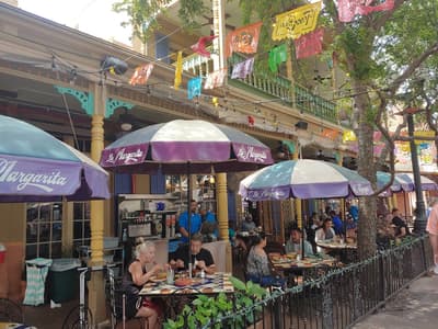
Mexican-style marketplace with crafts, food stalls and weekend music.

Hotel Emma's bar in the old brewhouse, with intimate booths in vintage tanks.

Hotel in the Pearl's 1894 brewhouse, keeping the old machinery in its lobby, with a library bar and rooms on the river.
Give it two days to fit a Franklin line, a Lockhart side trip, a Barton Springs swim and live music.
Where Austin → San Antonio sits in the full itinerary. Highlighted stops are this leg.
Smoke, spice & southern charm
This is leg 2 of 2, the final leg.
Going the other way? San Antonio to Austin is the same 118 km in a straight line, heading north-east. Reverse directions in Google Maps ↗
The biggest gap comes in February, when San Antonio averages highs 2°C warmer than Austin.
| Measure | Jan | Feb | Mar | Apr | May | Jun | Jul | Aug | Sep | Oct | Nov | Dec |
|---|---|---|---|---|---|---|---|---|---|---|---|---|
| Austin high | 16° | 18° | 23° | 27° | 31° | 34° | 36° | 37° | 32° | 28° | 22° | 17° |
| San Antonio high | 17° | 20° | 24° | 29° | 32° | 35° | 36° | 36° | 32° | 28° | 23° | 18° |
| Austin rain | 58 | 45 | 73 | 63 | 111 | 78 | 60 | 63 | 87 | 95 | 59 | 49 |
| San Antonio rain | 49 | 36 | 61 | 62 | 100 | 71 | 71 | 62 | 95 | 78 | 49 | 45 |
Temperatures in °C, rain in mm per month. Long-term monthly averages from NASA POWER satellite climatology — a guide to typical conditions, not a forecast. Month headings link to San Antonio month guides.
Austin is about 118 km (74 mi) from San Antonio in a straight line, with San Antonio to the south-west. By road, we estimate 142–166 km (88–103 mi), or 1.2–1.4 times the straight line. Check a maps app for the exact route.
An estimated 1 h 30 min – 2 h 30 min, assuming 142–166 km of road at average speeds of 65–95 km/h with no stops or traffic. It is not a routed time, so check a maps app on the day.
Our Texas BBQ Trail itinerary includes this leg. Texas BBQ Trail runs about 5 days across 3 stops, best in Oct – Apr.
Add this leg to a shared itinerary, poll the group on where to stop, split fuel and tickets, and keep everyone's packing list in one place in TripsCircle.