

Oklahoma, United States
Wichita Mountains
Spend a full day for the summit drive, a hike among bison and longhorns, and dinner in cobblestone Medicine Park. Below: 4 sights, 1 activity and 2 outdoor spots, plus how Wichita Mountains fits into a longer trip.

- Places
- 10
- Curated routes
- 1
- Best season
- Mar – May
- Warmest month
- July
- Coolest month
- January
- Wettest month
- May
4 See · 1 Do · 2 Outdoors · 2 Eat · 1 Drink
Oklahoma Route 66
from our route notes
35°C / 95°F avg high
10°C / 50°F avg high
about 115 mm rain
Climate: NASA POWER 2001–2025 averages.
Things to do in Wichita Mountains
10 places from our curated routes, grouped by what you will do there. Each one has its own page with the address and full notes.
See
The landmarks we would not skip in Wichita Mountains across Wichita Mountains and Medicine Park. All 4 are free to visit.
 Photo: Morne Erasmus · GoogleSee
Wichita Mountains Wildlife Refuge Visitor Center
Starting point for maps, trail conditions and exhibits on the refuge's prairie and bison.
Tip Ask about current wildlife sightings.
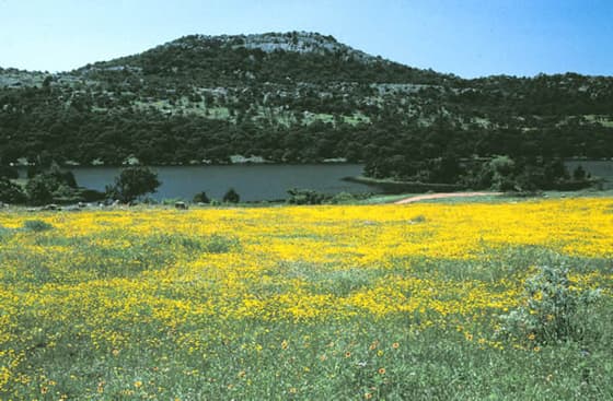 Photo: Wikimedia Commons · Public domainSee
Mount Scott
Paved road to a 2,464-foot summit with views over lakes and prairie.
Tip Road closes to cars at times on busy weekends; go early.
 Photo: Larry Smith · CC BY 2.0See
Holy City of the Wichitas
Stone chapel and Passion play set built in the 1930s.
Tip Free; hosts an Easter pageant.
 Photo: Jphill19 · CC BY-SA 3.0See
Medicine Park
Small cobblestone resort town on Medicine Creek, Oklahoma's first.
Tip Walk the creekside paths and cobblestone shops.
Do
Hands-on ways to spend time in Wichita Mountains in Charons Garden.
 Photo: A. D. · GoogleDo
Elk Mountain Trail
Popular 2-mile round-trip climb to granite boulders and a summit view.
Tip Start at Sunset Picnic Area; sturdy shoes needed.
Outdoors
Trails, views and open space in and around Wichita Mountains. All 2 are free to visit.
 Photo: Mumen Rider · GoogleOutdoors
Charons Garden Wilderness
Rugged boulder-strewn wilderness area with scrambles and canyons.
Tip Trails are faint; carry a map and water.
 Photo: Matthew Matyjek · GoogleOutdoors
Forty Foot Hole
Granite gorge and pool on Cache Creek reached by short trail.
Tip Swimming not allowed; slick rocks after rain.
Eat
2 places to eat in Medicine Park, picked for groups who care about the food.
 Photo: The Old Plantation Restaurant · GoogleEat
The Old Plantation Restaurant
Medicine Park steakhouse serving since 1966 in a 1910 building.
Tip Get the hand-cut ribeye and peach cobbler.
 Photo: Riverside Cafe · Google
Drink
1 bar or café in Medicine Park for coffee, a round or a nightcap.
 Photo: Terry Head · Google
How to fit Wichita Mountains into a trip
Wichita Mountains is stop 3 of 3 on our Oklahoma Route 66 route. Follow it as-is or lift Wichita Mountains into your own plan.
Stop 3 of 3
Oklahoma Route 66
Neon landmarks, creative cities & granite peaks
- Trip length
- 6 days
- Best season
- Mar – May
- Pace
- easy
- Before: Oklahoma City
Getting here and onward
- Oklahoma City to Wichita MountainsOklahoma City is about 136 km / 84 mi away in a straight line
Distances are straight-line estimates between destination centers, not road distances.
Wichita Mountains month by month
Average daily highs run from 10°C / 50°F in January to 35°C / 95°F in July. May is the wettest month, with about 115 mm of rain. Outlined months fall in the best season on our routes.
- Jan10° / 50°F average high
- Feb12° / 54°F average high
- Mar18° / 65°F average high, in our recommended season
- Apr24° / 75°F average high, in our recommended season
- May28° / 82°F average high, in our recommended season
- Jun33° / 91°F average high
- Jul35° / 95°F average high
- Aug35° / 94°F average high
- Sep30° / 85°F average high
- Oct23° / 74°F average high
- Nov16° / 62°F average high
- Dec10° / 50°F average high
Average daily highs, NASA POWER 2001–2025 averages. Wichita Mountains weather and the best time to visit →
Near Wichita Mountains
7 other destinations from our guides within about 300 km (186 mi), measured in a straight line.
- Downtown OKC & BricktownOklahoma, United States135 km / 84 mi
- Oklahoma CityOklahoma, United States136 km / 84 mi
- Lake HefnerOklahoma, United States137 km / 85 mi
- Downtown Dallas & Reunion TowerTexas, United States281 km / 174 mi
- DallasTexas, United States281 km / 175 mi
- Bishop Arts DistrictTexas, United States282 km / 175 mi
- TulsaOklahoma, United States292 km / 182 mi
Wichita Mountains questions, answered
How many days do you need in Wichita Mountains?
Our route notes suggest a full day in Wichita Mountains. On our Oklahoma Route 66 route it is stop 3 of 3 in a 6-day trip. The listed visit times for our 10 places add up to roughly 12 hours, before travel between them, so you will need to choose.
What is Wichita Mountains best known for?
Spend a full day for the summit drive, a hike among bison and longhorns, and dinner in cobblestone Medicine Park. Standouts on our list: Wichita Mountains Wildlife Refuge Visitor Center (Starting point for maps, trail conditions and exhibits on the refuge's prairie and bison); Mount Scott (Paved road to a 2,464-foot summit with views over lakes and prairie); Holy City of the Wichitas (Stone chapel and Passion play set built in the 1930s).
When is the best time to visit Wichita Mountains?
Our Oklahoma Route 66 route is best Mar – May. NASA POWER 2001–2025 averages put the warmest highs in July (35°C / 95°F), the coolest in January (10°C / 50°F) and the most rain in May (about 115 mm).
What are the best things to do in Wichita Mountains?
Start with Wichita Mountains Wildlife Refuge Visitor Center, Mount Scott, Elk Mountain Trail, Charons Garden Wilderness and Forty Foot Hole. Our guide lists 10 places in all, from 4 sights, 1 activity, 2 outdoor spots, 2 places to eat and 1 bar or café.
Where should a group eat in Wichita Mountains?
Our picks: The Old Plantation Restaurant (Medicine Park); Riverside Cafe (Medicine Park). Get the hand-cut ribeye and peach cobbler (The Old Plantation Restaurant).
What is near Wichita Mountains?
The closest destinations in our guides are Downtown OKC & Bricktown (about 135 km / 84 mi), Oklahoma City (about 136 km / 84 mi) and Lake Hefner (about 137 km / 85 mi). Distances are straight-line estimates, not road distances.
Plan Wichita Mountains with your crew
Open the Oklahoma Route 66 route in TripsCircle, invite friends with a link, settle which of these 10 places make the cut with a quick poll, then split costs and share one packing list.
Plan around Wichita Mountains
- Oklahoma travel hub
- United States travel hub
- Best Restaurants in Oklahoma 10 places
- Top Things to Do in Oklahoma 21 places
- Best Outdoor Spots in Oklahoma 7 places
- Best Restaurants in United States 502 places
- Best Bars & Cafés in United States 258 places
- Top Things to Do in United States 919 places
- Best Outdoor Spots in United States 326 places
- Best Shopping in United States 71 places
- Wichita Mountains weather by month
More in United States
- Eureka Springs 9 places
- Texas Hill Country 8 places
- Zilker Park & Barton Springs 6 places
- Austin 9 places
- Downtown Austin & Lady Bird Lake 7 places
- Branson 9 places
- Springfield 8 places
- Lawrence 9 places